Manaslu Circuit Trek Overview: Everything You Need to Know Before You Go
A clear route map is not just helpful for the Manaslu Larkya Pass Trek- it’s essential. Manaslu Trek is a remote and restricted area circuit where trails pass-through high-altitude pastures, glacial valleys, and villages that see few outsiders. Without a solid understanding of the route, trekkers risk missing side trails, misjudging acclimatization days, or even getting turned back at checkpoints. That is why we have built this guide around a detailed itinerary and easy to follow map.
Manaslu Larkya La Pass Trek traces an anticlockwise loop around Mt. Manaslu (8,163 m), the world’s eighth highest peak, with the journey’s high point at Larkya La Pass (5,106 m). Trekkers will start at Machha Khola (890 m), climb through Jagat, Deng, Namrung, Shyala, and Samagaun, push across the Larkya pass via Samdo and Dharamsala, then descend through Bimthang, Tilje, and out at Besisahar (2,300 m). Total trekking distance covers 160–177 km depending on your itinerary, and typically takes 12–14 days, or 16–18 if you add the Tsum Valley extension.
In this guide, you will get an interactive style map description, a clear elevation profile, stage by stage breakdowns with real trail conditions, and notes on side trips like Pungyen Gompa and Manaslu Base Camp. We have updated everything for 2026 road access changes and the latest permit rules so you are not relying on outdated info. At Mount Face Nepal, we have led dozens of groups through this circuit and know exactly where the trail narrows, which teahouses are good, and how to time your pass crossing for the best weather, details that turn a tough trek into an unforgettable journey.
Manaslu Circuit Trek Quick Facts 2026
| Details | Manaslu Larkya Pass Route |
| Start | Machha Khola (890 m) |
| End | Dharapani (1,860 m) |
| Highest Point | Larkya La Pass (5,106 m) |
| Total Distance: | 130–177 km (depending on side trips) |
| Duration | 12–16 days |
| Difficulty | Moderate to Challenging |
| Direction | Anticlockwise |
| Required Permits | RAP + MCAP + ACAP |
Manaslu Larkya Pass Trek Route Map Explained
Understanding the Route Shape (Horseshoe Around Manaslu)
The Manaslu Larkya Pass Trek isn’t a straight line, it’s a deliberate horseshoe loop that wraps counterclockwise around Mt. Manaslu (8,163 m). This shape isn’t accidental, it follows the ancient trade routes, respects sacred geography and maximizes acclimatization by gaining elevation gradually before the high pass.
Gorge Section (Machha Khola- Namrung)
The first stretch follows the Budhi Gandaki River as it carves deep through subtropical forests and terraced farms. You will start in lowlands around 890 m and climb steadily through villages like Jagat and Deng, watching the landscape shift from rice paddies to pine and rhododendron forests. By the time we reach Namrung (2,630 m), the air is crisper, prayer flags appear more often and first hints of Tibetan culture begin to surface along the gorge wall.
Nupri Valley (Namrung - Samdo)
Leaving the gorge behind, the trail opens into the Nupri Valley, a high altitude basin steeped in Tibetan Buddhist Tradition. Villages like Lho and Samagaun sit beneath towering peaks, with ancient gompas, mani walls, and the first clear views of Manaslu itself. Elevation climbs from 2,630 m to 3,860 m at Samdo, which is the last permanent settlement before the pass. This is where the culture feels most distinct with yak herders, barely fields and monasteries that have stood for centuries.
High Pass Section (Samdo - Bimthang)
From Samdo, the landscape turns stark and alpine as we push toward Larkya La Pass (5,106 m). The trail crosses barren moraines, glacial streams and ridges with little vegetation, just ice, rock and sky. You will spend overnight at Dharamsala (4,460 m) before the big crossing. Then descend into the remote village of Bimthang (3,790 m). This is the trek’s most demanding stretch, requiring good weather, proper acclimatization and steady legs.
Descent Valley (Bimthang - Besisahar)
After crossing the pass, the trail drops quickly into the Marsyangdi valley, transferring barren heights for lush rhododendron forests and flowing waterfalls. During this section, you will also pass through traditional Gurung and Tamang villages like Tilje before reaching Dharapani or Besisahar, where the Manaslu Circuit meets the Annapurna Circuit Trail. The air finally starts to feel warmer, the paths get wider, and the pace relaxes as you are now near to the end of Manaslu trekking journey.
Manaslu Circuit Trek Day-by-Day Route: Village-by-Village
Day 01: Drive Kathmandu to Machha Khola (890 m)
Distance: 157 km | Duration: 9–10 hours | Terrain: Asphalt, packed gravel, dirt track, single-lane off-road
A long but scenic road day takes you from the capital deep into the Budhi Gandaki valley. The journey starts on smooth highways and gradually turns into a rough 4WD adventure, ending at the trailhead ready for the trek.
Section 1: Kathmandu to Malekhu & Benighat :The morning begins with an early drive out of Kathmandu Valley via Nagdhunga on the paved Prithvi Highway. For about 80 km and 3.5–4 hours we will follow the winding Trishuli River passing terraced farms, concrete bridges, and busy market towns like Galchi, Malekhu, and Benighat. Heavy truck traffic and occasional roadwork slow the pace, but sunrise over the lower hills and a riverside stop for masala tea or breakfast makes the journey really pleasant.
Section 2: Benighat / Galchi to Dhading Besi to Arughat: Leaving the main highway, the road shifts from smooth paved to bumpy and then rough dirt and gravel for roughly 45 km and 2.5–3 hours. You climb through subtropical forests, bamboo groves, and banana plantations passing rural Gurung and Magar hamlets to Dhading Besi, then descend toward Arughat Bazaar on the Budhi Gandaki.
Section 3: Arughat to Soti Khola to Machha Khola:The final 32 km stretch takes 3–3.5 hours on a narrow off-road dirt track with exposed bedrock, mud or dust ruts, and cliffside cutouts. The landscape gets narrows into the steep Budhi Gandaki gorge, where roadside waterfalls spill onto the track and high suspension bridges appear in the distance. Slow low-gear driving past Soti Khola brings us to Machha Khola teahouse, where we can organize gear and enjoy a hot dinner by the river.
Day 2: Trek from Machha Khola to Jagat
Distance: 17 km | Duration: 6–7 hours | Terrain: Rocky single-track, stone steps, suspension bridges, sandy riverbed
Today the walking begins along the Budhi Gandaki river. The trail mixes riverbanks, stone stairs, and suspension bridges, ending at the first official checkpoint village of Jagat.
Section 1: Machha Khola to Tatopani & Dobhan:A gentle 6 km morning walk of about 2 hours follows a narrow dirt path and river-stone staircases through lush subtropical forest filled with sal trees and wild orchids. We will pause at Tatopani’s natural hot springs, cross suspension bridges, and dodge donkey trains on narrow ledges before reaching the sandy riverbed at Dobhan for a short tea break beside the roaring water.
Section 2: Dobhan to Yaruphant & Cantilever Bridge:The next 5.5 km take roughly 2 hours across fine gravel, boulders, and switchbacks. The major highlight here is the high suspension bridge, letting us to walk high above the river. Open gravel plains and views of fishermen accompany the path to Yaruphant and the Yaru Khola bridge, with pack animals sharing the trail.
Section 3: Yaruphant to Tharo Bharyang to Jagat:The final 5.5 km and 2.5 hours climb continuous stone steps also known as Tharo Bharyang (“Steep Ladder”), then ease onto paved pathways passing millet and maize terraces. The flora shifts toward pine and oak as we cross suspension bridges and register permits at the Jagat MCAP checkpoint before exploring the village’s clean stone-paved streets.
Day 3: Trek from Jagat to Deng
Distance: 19 km | Duration: 7–8 hours | Terrain: Stone steps, pine forests, narrow gorge trails, multiple suspension bridges
The trail leaves the lower gorge and enters cooler pine forests, with the first clear signs of Tibetan Buddhist culture appearing along the way.
Section 1: Jagat to PhilimWell-maintained flagstone paths and mild staircases cover 6 km in about 2 hours through green valleys and cascading waterfalls. Sprawling terraces of corn and barley leads us into the large Gurung village of Philim, where you pass schools, monasteries, and enjoy panoramic canyon views over a cup of tea after the morning permit check.
Section 2: Philim to Ekle Bhatti & Tsum Valley Junction: A high balcony trail cut into the cliff walls takes about 6.5 km and 2.5 hours through dense blue-pine, rhododendron, and fir forest. The canyon narrows dramatically at Ekle Bhatti. Here we can find a major suspension bridge that marks the trail junction where the route to the hidden Tsum Valley branches east while we continue on the Manaslu Circuit.
Section 3: Tsum Junction to Nyak, Pewa & Deng:The remaining 6.5 km and 3 hours wind through scree slopes, landslide bypasses, and log bridges in shady pine canyons. Early mani walls and carved chortens appear as the path turns west past Nyak and Pewa, ending at the quiet stone village of Deng nestled among steep forested slopes.
Day 4: Deng to Namrung (2,630 m)
Distance: 19 km | Duration: 7–8 hours | Terrain: Forest trails, river crossings, steep stone staircases, alpine terrain
Today we will climb deeper into the Nupri region, crossing the cultural threshold into upper Tibetan-influenced country and gaining the first distant views of high Himalayan peaks.
Section 1: Deng to Bihi Phedi & Rana: During this first section, high cliffside tracks and damp forest paths cover 6 km in 2.5 hours through bamboo forests and buckwheat fields. We cross the Deng Khola, pass the small Tibetan-style villages of Rana and Bihi Phedi, and pause to admire intricately carved mani stones while local farmers tend their livestock.
Section 2: Bihi Phedi to Ghap: Multiple high suspension bridges and squeeze-canyon trails make up the next 6.5 km and 2.5 hours to reach Ghap. Here, mossy pines and prayer shrines line the route. Here, we will walk left of the mani walls (Anti Clock Wise) respecting Buddhist culture, stop for lunch in Ghap, and photograph the detailed Buddhist carvings.
Section 3: Ghap to Namrung: Soft pine-needle paths will give way to steep continuous stone staircases for the final 6.5 km and 2.5–3 hours. Blooming rhododendron forests open suddenly to views of Siringi Himal and the Ganesh range here. Here, we will pass under the painted Kani gate into Namrung’s stone streets, marking entry into the upper Nupri cultural zone.
Day 5: Namrung to Shyala (3,500 m)
Distance: 18 km | Duration: 7–8 hours | Terrain: Alpine dirt tracks, stone steps, pine forests, open mountain pastures
Alpine scenery takes over as Mount Manaslu finally reveals its full massive form and the trail climbs into open high pastures.
Section 1: Namrung to Lihi: A gradual 5 km walk of about 2 hours follows alpine dirt tracks and stone pathways passing long mani walls and chortens. Vibrant green-and-gold barley terraces climb the hillsides around Lihi village, with clear views of Simnang Himal providing a peaceful start to the day.
Section 2: Lihi to Lho (Lho-Gaon) :After dropping into a side valley and crossing the Hinan Khola on a wooden bridge, a steep 6 km switchback climb of 2.5 hours on dirt and loose rock brings the summit of Manaslu (8,163 m) into full view. In Lho we will visit the hilltop Riba Gompa monastery, meet monks, and take photos of the towering peak.
Section 3: Lho to Shyala: The final 7 km and 3 hours descend briefly through fir forest, then climb steadily across open pastures and birch woods above 3,000 m. Yak herds graze among small junipers as a 360-degree amphitheater of peaks—Manaslu, Peak 29, and Himalchuli unfolds in breathtaking view, ending at the quiet alpine settlement of Shyala with its dramatic sunset views.
Day 6: Shyala to Samagaun (3,585 m) + Pungyen Monastery Visit
Distance: 17 km (including side trip) | Duration: 6–7 hours | Terrain: Alpine trail, glacial lateral moraine, rocky tracks, stream crossings
A side trip to a dramatic high monastery is the major highlight of this day during Manaslu Trek itinerary before settling into the largest village of the Nupri region for two nights.
Section 1: Shyala to Pungyen Junction & Valley Approach::A gentle 4 km downhill of 1.5 hours crosses open alpine and a wooden bridge over a glacial river. Wide yak pastures and the giant east face of Manaslu dominate the view before we turn left onto the side trail toward Pungyen Glacier.
Section 2: Pungyen Junction to Pungyen Monastery & Back:The 8 km round-trip climb of 3.5–4 hours follows a steep narrow path along the lateral moraine through wind-blown scrubland. At the secluded plateau (around 4,000 m) the rebuilt. Pungyen Monastery sits on a high plateau with expansive views toward Manaslu and the surrounding glaciers. Here we explore the quiet gompa, eat a lunch, and return the same way.
Section 3: Main Junction to Samagaun:An easy 5 km flat walk of 1.5 hours follows wide gravel riverbeds and long mani-stone walls into Samagaun. The largest village of Nubri valley welcomes us with stone houses, Labrang Monastery, and different teahouses that will serve as your base for the acclimatization day ahead on Manaslu Circuit Trek.
Day 7: Acclimatization Day in Samagaun – Hike to Manaslu Base Camp (4,800 m) and Birendra Lake
Distance: Variable 10-12 km round trip | Duration: 6–7 hours | Terrain: Steep glacial moraine, scree, loose rock, ice-adjacent alpine paths
A high side hike helps your body adapt before the pass, offering close encounters with glaciers and the world’s eighth-highest peak.
Section 1: Samagaun to Birendra Lake (3,450 m):A short 1.5 km stroll of 45 minutes crosses flat pasture then climbs a low moraine to the turquoise glacial lake. Calm morning waters of Birendra Lake perfectly reflect the Manaslu’s ice walls, providing a peaceful warm-up and photo stop before the steeper work begins.
Section 2: Birendra Lake to Mid-Moraine Ridge:The next 3.5 km and 2 hours rise steeply on narrow dirt-and-gravel switchbacks and loose scree on Manaslu Trek route map. Looking back, Birendra Lake shrinks below while the Nupri Valley and border peaks expand. Here, trekking poles become very helpful on the unstable surface.
Section 3: Mid-Moraine to Manaslu Base Camp (4,800 m) & Descent back to Samagaun: The final push and return cover about 7 km in 3.5–4 hours across rocky moraine, granite boulders, and ice-adjacent trails. At Base Camp we will stand beneath Manaslu’s summit wall among possible expedition tents, enjoy unreal views, then carefully descend the same steep slopes back to Samagaun for rest and recovery.
Day 8: Samagaun to Samdo (3,860 m)
Distance: 12 km | Duration: 4–5 hours | Terrain: Broad River valley, gentle alpine inclines, wide gravel paths, wooden bridges
A short, gentle day keeps the body adapting while the landscape opens into high altitude near the Tibetan border.
Section 1: Samagaun to Valley Plain & Juniper Pastures:An easy 4 km walk of 1.5 hours follows flat stone and dirt paths across the wide braided riverbed. Low juniper bushes. Yaks graze along the banks and old stone enclosure walls line the route, giving a relaxed recovery start.
Section 2: Valley Plain to Budhi Gandaki River Crossing:Another 4 km and 1.5 hours of soft dirt paths and alpine brush leads us to the wooden bridge where we will cross over the narrowing Budhi Gandaki. Samdo Peak and the high ridges toward Tibet fill the northern horizon as we cross the river for one last time in crisp mountain air.
Section 3: River Crossing to Samdo & Ridge Hike: Short steep switchbacks on a dry hill cover the remaining distance (including a ridge walk) in 1.5–2 hours. Prayer-flag chortens mark the entrance to Samdo, a traditional Tibetan refugee village of clustered stone houses. After lunch we will take a gentle acclimatization stroll up the ridge for glacier and border views.
Day 9: Samdo to Dharamsala / Larkya Phedi (4,460 m)
Distance: 14 km | Duration: 5–6 hours | Terrain: Exposed mountain ridges, rocky glaciated terrain
The trail climbs into pure alpine barrens, reaching the last high camp before the great Larkya La pass crossing.
Section 1: Samdo to Budhi Gandaki Final Bridge & Larkya Bazaar Ruins:A brief downhill of 4 km in 1.5 hours bring us across the Budhi Gandaki river where we will cross it on a wooden bridge. Beyond lie the stone foundations of the old Larkya Bazaar, once a busy salt-and-wool trading post.
Section 2: Larkya Bazaar to Larkya Glacier Moraine Ridge:Steady uphill gravel and scree for 5 km and 2 hours follow the high lateral moraine above the icy area of the Larkya Glacier. Frozen glaciers, Naike Peak, and Cheo Himal dominate the view.
Section 3: Moraine Ridge to Dharamsala (Larkya Phedi):The final 5 km and 2 hours climb steep gravel takes us into high basin. Basic stone shelters and tents awaits for us at Dharamsala (4,460 m). If we arrive early, we will drink garlic soup, pack headlamps and warm layers, and sleep early for the pre-dawn start.
Day 10: Dharamsala (4,460 m) to Bimthang (3,790 m) via Larkya La Pass (5,106 m)
Distance: 18 km | Duration: 8–9 hours | Terrain: Steep snow/ice/scree trails, high-altitude pass, steep rocky descent, glacial moraine
Today is the hardest and most rewarding day on Manaslu Larkya Pass Trek route. It is a pre-dawn ascent to the highest point of the trek followed by a long descent into a new valley.
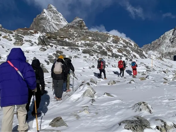
Section 1: Dharamsala to Larkya La Summit (5,106 m):Starting in darkness around 3:30–4:00 a.m., the 7 km climb of 4–5 hours crosses frozen scree, snowfields, and false-summit ridges under headlamp light. Sunrise paints Himlung, Cheo Himal, Kang Guru, and Annapurna II in unreal golden color as we reach the prayer-flag-draped summit of Larkya La at 5,106 m for photos and celebration.
Section 2: Summit Descent to Salpudanda Glacial Moraine:A very steep 5 km descent of about 2 hours drops over loose scree, hard snow, and ice switchbacks onto the rocky moraine of the Salpudanda Glacier. Trekking poles are essential here and oxygen level returns with every step as icefalls catch the morning sun and the western valley opens below.
Section 3: Moraine Ridge to Bimthang Valley:The final 6 km in 2 hours are easy as we are descending. Soft meadow floors leads us into the broad valley of Bimthang (3,790 m). Here, we will remove heavy layers, settle into a teahouse, and enjoy a well-earned warm meal while looking back at the pass.
Day 11: Bimthang to Tilje and Drive to Besisahar (2,300 m)
Distance: 14 Km Trek + 50 Km Drive| Duration: 7-8 hours total | Terrain: Pine/rhododendron forest trails, wooden bridges, dirt jeep roads
A long downhill walk through changing forests ends the trekking portion and a jeep then carries us out of the mountains.
Section 1: Bimthang to Karche & Gho:Sustained downhill stone stairs and mossy forest trails cover 8 km in 2.5 hours along the Dudh Khola. Dense rhododendron, pine, and fir give way to rear views of Manaslu’s south face where wooden bridges cross streams. At Gho village, we will take a short tea break before continuing towards Tilije
Section 2: Gho to Tilje :Another 6 km and 1.5–2 hours of dirt and flagstone paths passes apple orchards and terraced fields into the prosperous Gurung village of Tilje. A steel suspension bridge crossing will leads us to the Marshyangdi confluence at Dharapani, where the Manaslu trail joins the Annapurna Circuit. Here, we will register at the exit checkpoint and meet your jeep.
Section 3: Drive from Tilje to Besisahar:A bumpy 35 km, 2.5–3 hour 4WD ride follows a rough dirt track cut into the Marshyangdi gorge cliffs, following waterfalls, Chamje, and Jagat village before the valley opens into rice paddies. Late afternoon arrival in Besisahar (2300 m) brings a hotel, hot shower, and celebration of finishing the trek.
Day 12: Drive Besisahar to Kathmandu (1,400 m)
Distance: 175 km | Duration: 7–8 hours | Terrain: Paved highway, winding hill roads, urban traffic
A full day of comfortable highway travel returns travelers to the capital and modern comforts after two weeks in the mountains.
Section 1: Besisahar to Dumre Junction:Smooth paved roads cover 42 km in about 1.5 hours along the Marshyangdi through rolling green hills and fruit orchards. Rural villages and tropical scenery replaces the high mountains. This section ends at Dumre junction where we join the main Prithvi Highway.
Section 2: Dumre to Benighat & Malekhu: The next 75 km and 3 hours on return journey of Manaslu Circuit Trek follow the double-lane Prithvi Highway along the Trishuli River passing Mugling and busy roadside stalls. Occasional roadwork and truck traffic can make journey little slow. Near Malekhu, we will take a riverside lunch stop which lets us to watch white-water rafting groups while enjoying a final dal bhat.
Section 3: Malekhu to Nagdhunga Pass & Kathmandu:The last 58 km and 2.5–3 hours climb the winding Naubishe that switchbacks to the valley rim at Nagdhunga, then drop into the congested multi-lane traffic of Kalanki and Thamel. Pine hills give way to city streets. By late afternoon or evening you reach your hotel, drop the gear, and relax into soft beds and hot showers, making the comfortable end of the Manaslu Larkya La Trekking journey.
Altitude Sickness Risk Zones on Manaslu Circuit Trek
Low Risk Zone: Machha Khola to Namrung (below 2,630m) – AMS is unlikely
Moderate Risk Zone: Namrung to Samdo (2,630m-3,860m) – AMS possible with monitor symptoms
High Risk Zone: Dharamsala to Larkya Pass (4,460m-5,106m) – AMS is likely without proper acclimatization
How difficult is Manaslu Circuit Trek Route? Honest 2026 Review
The Manaslu Larkya La Pass trek is physically demanding but is manageable with the right preparation. At over 5,100 meters, the thin air makes every step feel heavier, and pass-crossing day can stretch to 8–10 hours of steep, rocky, sometimes icy terrain in cold and unpredictable weather. However, there’s no technical climbing required and no ropes or ice axes are needed. With good fitness, proper acclimatization days built in, and an experienced guide by your side, even beginners who train ahead of time can complete this challenging but deeply rewarding journey.
Best Time for Manaslu Larkya La Pass Trek: Month-by-Month Weather & Seasonal Guide
The best time for the Manaslu Larkya Pass trek are autumn (September to November) and spring (March to May). Autumn delivers stable skies, crisp air, and the sharpest views of Manaslu and surrounding peaks, plus it is the safest, most reliable conditions for crossing the 5,106 m pass. Spring brings milder temperatures, longer days, and rhododendron blooms along lower sections. However, its important that travelers avoid monsoon (June to August) as it brings muddy and landslide-prone trails, and winter (December to February) where deep snow and freezing temperature can block the pass entirely.
Best Viewpoints Along Manaslu Larkya Pass Route
| Location | Elevation | What you will see | Best Time |
| Lho Village | 3,180m | First full Manaslu south face | Late afternoon |
| Shyala | 3,500m | 360° glacial valley, Himal Chuli, Ngadi Chuli | Sunrise/sunset |
| Samagaun | 3,530m | Manaslu north face, Pungyen Glacier | Late afternoon light |
| Birendra Lake | 3,450m | Turquoise glacial lake, Manaslu reflection | Morning (calm water) |
| Pungyen Gompa | 4,040m | Manaslu Glacier, north face from monastery meadow | Midday (clear skies) |
| Larkya Pass summit | 5,106m | 360° panorama: Manaslu, Himlung, Kang Guru, Annapurna II | Summit morning |
| Bimthang | 3,728m | Manaslu and Ganesh Himal framing green valley | After pass crossing |
Larkya La Pass Crossing: Complete Route Guide for Trek's Hardest Day (5,106m)
Crossing Larkya La is the defining moment of the Manaslu Circuit and by far the toughest day on entire journey. You leave Dharamsala (4,460 m) before dawn and climb steadily over rocky moraines and wind-scoured ridges in freezing cold. The ascent takes four to five hours and the thin air makes every step feel heavier than it should. Reaching the summit at 5,106 m around sunrise rewards you with panoramic views of Manaslu, Cheo Himal, Kang La and more. From there, it’s a steep and knee-straining 3–4 hour descent to Bimthang (3,790 m), which is often on loose scree and icy patches.
This 8–10 hour day demands solid fitness, proper layers, and mental readiness. Weather can shift fast from clear skies one hour, while snowfall the next, so start early and keep moving. Carry high-energy snacks, warm gloves and trekking poles as it can be very helpful for the downhill sections. Your Mount Face Nepal guide keeps an eye out for altitude problems and adjusts the pace as needed. Yes, this part of Larkya La Pass Trek is exhausting, but standing on that pass with the Himalayas stretching in every direction makes every difficult step worthwhile creating a true sense of pride and accomplishment.
What Mountain Views can be seen on Manaslu Circuit Trekking Route?
The Manaslu Circuit delivers some of Nepal’s most dramatic peak views, anchored by Mt. Manaslu itself, world’s eighth highest peak (8,163 m), which dominates the skyline for much of the trek. As you climb higher, you will also spot Cheo Himal (6,820 m), Kang Guru (6,981 m), and the sharp pyramid of Annapurna II in the distance. On clear days from Larkya La Pass, the panorama expands to include Himlung Himal, Cheo Himal, Larkya Peak and even distant glimpses of the Annapurna massif. It’s a 360-degree theater of snow and rock that few other treks can match.
Permits & Checkpoints Along the Manaslu Circuit Trek Route Map
Required Permits
Travelers will need three permits for the Manaslu Larkya Pass Trek, the Restricted Area Permit (RAP), the Manaslu Conservation Area Permit (MCAP), and the Annapurna Conservation Area Permit (ACAP).
Permit Costs
The cost for RAP is $100 USD for the first 7 days, plus $15 USD for each additional day during Autumn (September – November). For Winter / Spring / Summer (December – August), RAP costs $75 USD for the first 7 days, plus $10 USD for each additional day. The cost for MCAP is NPR 3,000 for foreign nationals and NPR 1,000 for SAARC nationals. Similarly, the cost for ACAP is NPR 3,000 for foreign nationals and NPR 1,000 for SAARC nationals.
Checkpoints
There are checkpoints at Jagat, Namrung, Samagaun, Samdo and Dharapani where they check your papers. Jagat is usually the important and acts as the main entry point. As of 2026 the RAP has to be arranged through a registered agency like Mount Face Nepal and you need a licensed guide with you. Keep all the permits with you the whole time. The good news is that Mount Face Nepal manage all of this permits as part of the package, so you don’t have to worry about arranging it.
Final Words
The Manaslu Larkya Pass Trek isn’t just another random trekking destination in Nepal. It’s a proper journey through some of the country’s most remote and culturally rich landscapes. Before starting journey, carry a good route map (or download one), look over the elevation profile, and plan your rest days properly. Pushing too hard or skipping the acclimatization stops can turn what should be an amazing trip into something risky. So, hire a licensed and experienced guide who knows the trail, the weather patterns, and the right teahouses.
With the right preparation, this circuit rewards travelers with silence, snow-capped giants, and villages that feel frozen in time. Take your time on the pass, listen to your body, and let the mountains set the pace. At Mount Face Nepal, we have organized trek on this route dozens of times with travelers from all over the world, and we know exactly how to turn a challenging trek into the trip of a lifetime, safely, smoothly, and with plenty of moments you can talk about for years.