Upper Mustang Trek Overview: Route, Highlights & Travel Guide
The Upper Mustang Trek is a journey into Nepal’s “last forbidden kingdom,” a high-altitude desert that stayed closed to outsiders until 1992. We will start in Kathmandu, fly to Pokhara and then Jomsom, and continue to Kagbeni, where the restricted area checkpoint marks the beginning of the Upper Mustang restricted zone. From there, the trail winds through ancient villages like Chele, Syangboche, Ghami, and Charang before reaching the walled capital of Lo Manthang (3,840 m). The full trek covers roughly 150 Km over 10–14 days, depending on your pace and how many side trips you add.
What makes this Upper Mustang Trekking route special isn’t just the distance or duration, it’s the shape of the journey itself. The trail traces a horseshoe loop around the deep Kali Gandaki gorge, following old salt-trade paths that once linked Tibet and Nepal. This route mainly sticks to ridgelines to avoid the gorge’s sheer cliffs, passes through valleys where Tibetan culture still thrives, and gains elevation slowly so your body can adjust.
at Mount Face Nepal have organized tour in this route for several years, and we know the little things that make a big difference such as which teahouses are better, where the wind hits hardest, and how to time your arrival in Lo Manthang for the best experience. We handle the permits, sort out the flights to Jomsom, and pair you with guides who know the local stories and speak with you in fluent language. With Mount Face Nepal, it’s less about ticking a box and more about stepping into a place that still feels like another world.
Upper Mustang Trek Route Quick Facts: Distance, Duration, Altitude & Permits
| Details | Upper Mustang Trekking Route |
| Start | Jomsom (2,743 m) |
| End | Jomsom (2,743 m) |
| Highest Point | Chogo La Pass(4280m) |
| Total Distance: | Roughly 150 km (depending on side trips) |
| Duration | 14–16 days |
| Difficulty | Moderate |
| Required Permits | RAP + ACAP |
Upper Mustang Trek Route Map Explained: Villages, Passes & Trail Details
Approach Section (Jomsom → Kagbeni, 2,743m–2,804m)
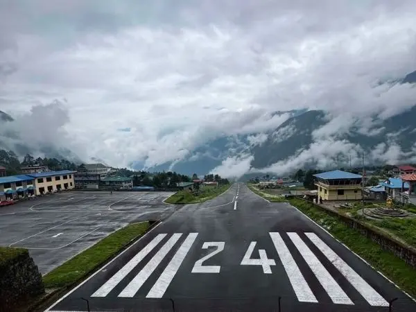
This first stretch of Upper Mustang Trek itinerary takes us from the windy airstrip at Jomsom up to Kagbeni, the gateway to Upper Mustang. The trail follows the Kali Gandaki River through lower Mustang villages with green fields and apple orchards. At Kagbeni, we hit the permit checkpoint—this is where the restricted zone officially begins, and our guide shows your documents before we cross the bridge north.
Gorge Section (Kagbeni → Chele → Syangboche, 2,804m–3,800m)
Kagbeni, the landscape shifts dramatically into the Kali Gandaki gorge which is also the world’s deepest gorge. We walk beneath towering red cliffs, pass ancient cave dwellings carved into rock faces, and start seeing prayer flags, chortens, and the first strong signs of Tibetan culture. On this Kagbeni to Lo Manthang route, villages like Chele and Syangboche sit in narrow side valleys, with teahouses that feel more remote and rugged than anything in lower Nepal.
High Valley Section (Syangboche → Lo Manthang, 3,800m–3,840m)
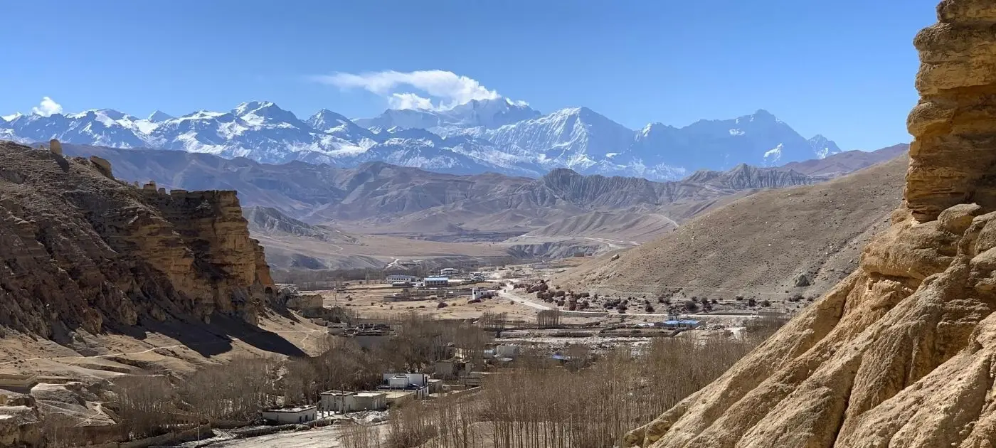
This is the heart of the “forbidden kingdom.” The trail opens into a wide, arid trans-Himalayan desert with almost no trees, just wind-sculpted earth, blue skies, and distant snow peaks. We pass through small settlements like Ghami and Charang before reaching Lo Manthang, which is a walled city frozen in time with narrow alleys, whitewashed houses, and centuries-old Tibetan Buddhist monasteries still in active use.
Return Circuit (Lo Manthang → Chhusang → Jomsom, 3,840m–2,743m)
the way back, we will take a different trail instead of retracing our steps. The Upper Mustang Trekking route loops south through Chhusang, where we can explore ancient cave complexes. The descent feels faster, the air is warmer, and we reach Jomsom with a real sense of having completed a full circle through one of the Nepal’s most unique landscapes.
Upper Mustang Trekking Route: Detailed Day-by-Day Itinerary
Day 01: Kathmandu (1,400 m) to Pokhara (822 m)
Distance: 200 km | Duration: 6–7 hours drive / 25–30 minutes flight | Terrain: Asphalt highway, winding hill roads, or aerial flight
Section 1: Kathmandu (1,400 m) to Mugling (255 m) : We will leave Kathmandu Valley at 1,400 m and drive west on the Prithvi Highway along the Trishuli River for about 110 km, taking 3–3.5 hours. The paved asphalt road has double lanes with heavy bus traffic and some roadwork delays. You see green hills, terraced farms, roadside bazaars, and river bridges. Near Malekhu or Mugling you stop for hot masala tea and snacks while watching rafters on the river.
Section 2: Mugling (255 m) to Pokhara (822 m):After Mugling the road continues about 90 km for another 3–3.5 hours, dropping through lower valleys toward Pokhara at 822 m. It crosses the Marshyangdi River into Tanahun district and passes Dumre and Damauli on mixed smooth blacktop and gravel detours. The air grows warmer with banana trees, bamboo, and villages on ridges. The road flattens as you enter Pokhara with clear views of the Annapurna Range and Machhapuchhre (Fishtail, 6,993 m). Overnight at Pokhara.
Flight Option: Kathmandu (1,400 m) to Pokhara (822 m)
The 25–30-minute flight skips the long road journey. From Tribhuvan International Airport, the aircraft travels west along the Himalayan foothills. On clear days, you may see Langtang, Ganesh Himal, Manaslu, and Annapurna before descending over Pokhara’s green hills. The flight distance is roughly 150 km, and the aircraft lands at Pokhara International Airport.
Day 02: Pokhara (822 m) to Jomsom (2,743 m) and Trek to Kagbeni (2,804 m)
Distance: 11 km (Trek) | Duration: 20 min flight / 6–8 hrs drive + 3–4 hrs trek | Terrain: Mountain flight path / rough off-road dirt track, flat riverbed gravel, loose sand, paved stone paths
Section 1: Pokhara (822 m) to Jomsom (2,743 m):We will start early with a transfer to Pokhara Airport for the 20-minute mountain flight to Jomsom at 2,743 m. The plane flies through the Kali Gandaki Gorge between Annapurna I (8,091 m) and Dhaulagiri (8,167 m). If weather stops the flight, a jeep drive (162 Km) of 6–8 hours takes the rough dirt track through Beni, Tatopani, and Marpha along rocky riverbeds and cliffside roads.
Section 2: Jomsom (2,743 m) to Ekle Bhatti (2,740 m):landing, trekkers will meet porters and arrange your trekking bags before walking north from Jomsom. The first 6–7 km takes around 2–2.5 hours along a wide, mostly flat trail beside the Kali Gandaki River. The surface includes packed gravel, rounded stones, loose sand, and occasional braided river channels. Strong afternoon winds may blow dust through the open valley, so a windproof jacket, scarf, and sunglasses are useful.
Section 3: Ekle Bhatti (2,740 m) to Kagbeni (2,804 m): final 4 km takes about 1–1.5 hours, with a gentle rise toward Kagbeni. We will cross small wooden bridges and continue beside gray cliffs, dry eroded slopes, willow trees, and the river’s wide gravel bed. Here we can witness Saligram fossils which are sacred to Hindu and Buddhist pilgrims. Kagbeni appears as a green oasis at 2,804 m, with stone paths, mud-brick walls, chortens, and the meeting point of the Kali Gandaki and Jhong Rivers. Overnight at Kagbeni.
Day 03: Kagbeni (2,804 m) to Chele (3,050 m)
Distance: 15 km | Duration: 5–6 hours | Terrain: Sandy riverbeds, dry dirt roads, steep cliffside cutouts, suspension bridge, uphill stone steps
Section 1: Kagbeni (2,804 m) to Tangbe (3,060 m):From here, we pass through the official restricted-area checkpoint at Kagbeni (2,804 m) and walk about 6 km in 1.5–2 hours along the eastern side of the Kali Gandaki River. The path mixes wide pebbly riverbed and rough dirt road cut into high dusty bluffs, staying dry, exposed, and wind-swept with loose rock and dry soil. Across the river we see ancient cave dwellings high in the cliffs. We reach Tangbe, a traditional village with green irrigated fields of buckwheat, barley, and apple orchards, and pass three color-coded chortens (red, black, white) before walking narrow cobblestone alleys between whitewashed mud-brick houses stacked with winter firewood.
Section 2: Tangbe (3,060 m) to Chhusang (2,980 m):From Tangbe we will continue about 4 km for another 1.5 hours across open desert terrain, then descend to Chhusang at 2,980 m. The path stays dry and open on dirt and loose rock. The valley widens and shows giant cliff walls of red, orange, and gray rock shaped into organ-pipe forms by wind. Chhusang sits where the Tetang River meets the Kali Gandaki. We pass traditional stone houses and small teahouses, then take a short break by the riverbank to view the cliff caves of Mebrak.
Section 3: Chhusang (2,980 m) to Chele (3,050 m):Beyond Chhusang we cover the final 4 km in 1–1.5 hours. The river narrows into a rocky canyon under a natural rock-arch bridge. We cross a long sturdy suspension bridge to the western bank, then climb steeply on a winding cliffside track of loose dirt, small scree, and carved stone steps hundreds of meters above the gorge on this Kagbeni to Lo Manthang route. At the top we enter Chele (3,050 m), a small ridge-top village with fortress-like stone houses and broad views down the Kali Gandaki canyon.
Day 04: Chele (3,050 m) to Syangboche (3,800 m)
Distance: 11 km | Duration: 6–7 hours | Terrain: Steep Mountain passes, narrow cliffside trails, scree slopes, deep canyons, stone steps
Section 1: Chele (3,050 m) to Samar (3,660 m): We will start with a steep uphill climb out of Chele (3,050 m) covering about 5 km in 2.5–3 hours along a narrow dry rocky path cut into the canyon wall toward Taklam La Pass (3,624 m). The track is exposed with loose dirt and small stones, so steady footwork is needed. Views look down into deep gorges and back to Nilgiri and Annapurna peaks. After Taklam La we will descent briefly then rise to Daji La Pass (3,660 m) through cold desert with low thorny bushes. We descend a winding scree path into Samar (3,660 m), a quiet village with poplar trees, streams, and horse stables where we take a short tea break.
Section 2: Samar (3,660 m) to Chungsi Cave (3,100 m) (Optional Tour): From Samar we will choose the classic trail and walk about 3 km in 1.5–2 hours, descending steep switchbacks of loose gravel and stone steps into a deep vertical gorge. The path drops to a quiet canyon floor surrounded by high cliffs. We reach Chungsi Cave, a sacred site where Guru Rinpoche meditated in the 8th century. Inside the cave we see natural rock shapes like Buddhist deities and stupas, plus butter lamps cared for by resident monks.
Section 3: Chungsi Cave (3,100 m) to Syangboche (3,800 m):We will climb back out on a steep zig-zag dirt path for the final 4 km for this day on Upper Mustang Trekking route in about 2 hours, passing small stands of pine and juniper before reaching Syangboche La Pass (3,850 m). Strong wind blows at the pass where colorful prayer flags fly over dry rolling hills toward Tibet. A short gentle downhill on a wide dusty track leads us into Syangboche (3,800 m), a small village of teahouses, stone stables, and family farms set in a high mountain bowl. We settle into the teahouse and sit by the warm stove as evening temperatures drop sharply.
Day 05: Syangboche (3,800 m) to Ghami (3,560 m)
Distance: 12 km | Duration: 5–6 hours | Terrain: High-altitude mountain passes, gentle dirt roads, rocky descents, open desert plateaus
Section 1: Syangboche (3,800 m) to Ghelung (3,860 m):We will leave Syangboche (3,800 m) and walk about 4 km in 1.5–2 hours on a gradual climb to Yamada La Pass (3,850 m). The path follows a broad unpaved road of packed soil and small stones through open treeless hills. Morning light shows dry land in shades of ochre, yellow, brown, and pink with clear sharp mountain views. After the pass we continue on a high ridge trail, contouring around slopes past small farming valleys with meltwater streams, mixing wide dirt tracks and narrow single-track across dry gullies and rock bluffs toward Ghelung.
Section 2: Ghelung or Ghiling (3,860 m) to Nyi La Pass (4,010 m):From near Ghelung we climb steadily about 4 km in 2 hours to Nyi La Pass (4,010 m), the highest point so far. Long switchbacks cross a dry wind-blown ridge. We pace ourselves carefully as we pass 4,000 meters. At the top we stop to take in wide views across Upper Mustang, looking north to the Tibet border ranges and south to the white ice wall of the Annapurna massif.
Section 3: Nyi La Pass (4,010 m) to Ghami (3,560 m):From Nyi La we descend about 4 km in 1.5–2 hours along a wide ridge toward Ghami La Pass (3,765 m) on dry earth, small gravel, and loose shale that needs careful steps. The land shows deep canyons, fluted cliffs, and tall rock towers. A final steady descent brings us into Ghami (3,560 m). It is large old village surrounded by green fields of buckwheat, barley, and mustard watered by the Ghami Khola. We pass stone chortens and whitewashed alleys, check into a teahouse, and explore the historic monastery and old stone houses.
Day 06: Ghami (3,560 m) to Charang / Tsarang (3,570 m)
Distance: 11 km | Duration: 4–5 hours | Terrain: Riverbed crossings, suspension bridge, scree climbs, flat desert plateau, dirt roads
Section 1: Ghami (3,560 m) to Mani Wall (3,650 m): We leave Ghami (3,560 m) and walk about 3 km in 1–1.5 hours, first descending a steep gravelly slope to the Ghami Khola riverbed. We cross the fast glacial stream on a sturdy steel suspension bridge, then climb sharply up a loose dirt track cut into a reddish-brown cliff face. The fine scree can feel little slick underfoot. At the ridge top we reach the famous Mani Wall of Ghami, which is the longest prayer stone wall in Nepal, over 300 meters long and covered with thousands of carved “Om Mani Padme Hum” stones. Local myth says it is the spine of a slain demoness and the red cliffs are stained with her blood. The trail runs beside the wall and three large painted chortens.
Section 2: Mani Wall (3,650 m) to Charang La Pass (3,870 m): From the Mani Wall we continue about 5 km in 2 hours, climbing gradually to Tsarang La / Charang La Pass (3,870 m). The path follows a wide open desert plateau on a broad unpaved track of packed dirt and small pebbles. The walk feels spacious and quiet with cool winds. To the north the land stretches toward the Tibetan border, cut by deep eroded canyons. After the pass we begin the descent on the same open track.
Section 3: Charang La Pass (3,870 m) to Charang (3,570 m): The final 3 km take 1–1.5 hours as we drop toward Charang (3,570 m) on a wide flat dirt road lined with ancient chortens, willow trees, and stone-walled fields. The village sits at the edge of a huge canyon with snow-capped peaks and multi-colored cliffs behind it. Charang was the second capital of the old Kingdom of Lo. We check into a teahouse, then walk the cobblestone streets to visit the 5-story white Palace of Charang from the 14th century and the large red Charang Monastery, which holds old Tibetan thangkas and statues.
Day 07: Charang (3,570 m) to Lo Manthang (3,840 m) via Lo La Pass (3,950 m)
Distance: 11 km | Duration: 5–6 hours | Terrain: Canyon descents, river crossings, gradual high-plateau climbs, wide dirt tracks, mountain pass
Section 1: Charang (3,570 m) to Charang Chu Crossing (3,500 m):We leave Charang (3,570 m) and walk about 2 km in 1 hour, descending a narrow dirt track through loose gravel and river-cut cliffs into the deep rocky canyon of the Charang Chu River. After crossing the river on a sturdy iron bridge we start the long steady climb onto the dry plateau that leads toward Lo Manthang.
Section 2: Charang Chu Crossing (3,500 m) to High Plateau (3,800 m):We continue about 5 km in 2.5–3 hours on a wide unpaved mountain dirt road that climbs gradually over gentle desert ridges. The high plateau feels open and exposed, with rolling hills in yellow, ochre, and gray. To the right we see sharp snow peaks of Nilgiri, Tilicho Peak, and Thorong Peak. The path is hard-packed earth with small pebbles and sparse alpine shrubs, allowing a steady comfortable rhythm as we gain height.
Section 3: High Plateau (3,800 m) to Lo La Pass (3,950 m): After roughly 4 hours of walking we climb the final 2 km in about 1 hour to Lo La Pass (3,950 m), also called the “Pass of Wind.” At the crest, colorful prayer flags mark the top. Suddenly the walled city of Lo Manthang appears below us, sitting in a wide flat plain with green fields, poplar trees, and distant Tibetan mountains. This first view is one of the biggest highlights of the whole trek.
Section 4: Lo La Pass (3,950 m) to Lo Manthang (3,840 m): Lo La Pass we walk the last 2 km in 1 hour on Lo Manthang trek route, descending gently on a broad gravelly slope past historic chortens and stone irrigation channels that feed barley and buckwheat fields. We cross a small glacial stream on a short wooden bridge and approach the tall northeast stone walls of the city. We enter Lo Manthang (3,840 m) through its massive ancient city gate, the historic main entrance. Inside, narrow paved stone alleys open between whitewashed mud-brick houses, monasteries, mani wheels, and local shops. We check into our teahouse and settle into the old capital of the Kingdom of Lo.
Day 8: Lo Manthang (3,840 m) Acclimatization: Explore Chhosar Cave (3,950 m) and Ancient Monasteries
Distance: 10–12 km (Round Trip) | Duration: 6-8 hours | Terrain: Flat dirt roads, sandy valley paths, steep carved cave steps
Section 1: Lo Manthang (3,840 m) to Chhosar Valley (3,900 m): After breakfast we will leave Lo Manthang (3,840 m) and head north about 5–6 km (2-3 hours) toward the Chhosar Valley near the Tibetan border. Here, trekkers will walk on the wide flat dirt road before taking steep stair climb up to caves. The path runs beside the Jhong Nala stream passing red-and-gold cliff faces, open pastures with yaks, and small villages like Garphu and Nyphu. The land stays open and dry with sandy stretches.
Section 2: Chhosar Valley (3,900 m) to Jhong Cave (3,950 m): we reach the main site, Jhong Cave (Chhosar Cave) at about 3,950 m, we can witness a 5-story cliff complex carved into a vertical rock wall thousands of years ago. We climb exterior stone stairs and interior wooden ladders to explore connected rooms, living quarters, storage, lookouts, and old ritual spaces once used as hideouts in war. Nearby we will also visit Nyphu Monastery built into a high cliff face and the quiet Garphu Monastery across the river.
Section 3: Jhong Cave (3,950 m) to Lo Manthang (3,840 m): After exploring caves and village on Lo Manthang trek route, we will return the same 5–6 km by mid-day, then spend the afternoon inside the city walls. We will visit the three main monasteries: Jampa Lhakhang (built 1387) with large gold-and-clay Buddha statues and floor-to-ceiling mandala murals, Thubchen Lhakhang (15th century) with its huge assembly hall and tall wooden pillars and Chodey Gompa, which is the active monastic school. We also walk along the 4-story Royal Palace, meet local monks and craftspeople, and see daily life of horse tending, wool spinning, and prayers. In the evening, we return to the teahouse for a hot meal of Tibetan meal, soup, or dal bhat.
Day 09: Lo Manthang (3,840 m) to Dhakmar (3,810 m) via Chogo La Pass (4,280 m) & Ghar Gompa
Distance: 16 km | Duration: 7–8 hours | Terrain: High-altitude Mountain pass, scree slopes, open desert tundra, valley descents
Section 1: Lo Manthang (3,840 m) to Chogo La Pass (4,280 m): We will leave Lo Manthang (3,840 m) and start a long climb of about 9 km in 3 hours on the western trail toward Chogo La Pass (4,280 m), the highest point of the whole Upper Mustang trek. The broad dirt path rises steadily across open mountain land on dry soil, small rocks, and sparse alpine scrub. Cool morning air and high elevation keeps our pace slow and steady. Reaching the top of Chogo La Pass (4,280 m) , it rewards you with magnificent panoramic views across the northern Mustang wilderness and back toward the snow peaks of the Annapurna range.
Section 2: Chogo La Pass (4,280 m) to Ghar Gompa (3,950 m): From the pass we will begin the long descent of about 4 km in 1.5–2 hours across open desert landscapes on dry earth, small gravel, and gentle slopes toward Ghar Gompa. Ghar Gompa (Lo Gekar Monastery) at 3,950 m, is located in very peaceful atmosphere. It is the oldest active Nyingma monastery in Nepal, built in the 8th century by Guru Rinpoche. We will explore its ancient carved stone prayer walls, colorful wooden murals, and calm atmosphere while monks perform daily rituals that have lasted over 1,200 years. After resting and taking tea at the monastery lodge we will continue a short climb over a ridge.
Section 3: Ghar Gompa (3,950 m) to Dhakmar (3,810 m): The final 3 km take about 1.5 hours as we drop steeply into the Dhakmar valley on switchbacking paths of fine red dust and scree. Giant blood-red sandstone cliffs rise above us, carved with hundreds of old meditation caves and natural fluted pillars. We will arrive in the peaceful village of Dhakmar (3,810 m) at the base of these red bluffs which is surrounded by green fields. Overnight at Dhakmar.
Day 10: Dhakmar (3,810 m) to Ghiling (3,570 m)
Distance: 15 km | Duration: 5–6 hours | Terrain: Dirt roads, ridge trails, mountain passes, rocky descents, village farm paths
Section 1: Dhakmar (3,810 m) to Mui La Pass (3,700 m): We will leave Dhakmar (3,810 m) early in the morning with the giant red cliffs behind us and walking for about 5 km in 1.5–2 hours. The trail starts on a pleasant flat dirt track beside the local stream through green barley fields. After the village it climbs steadily on winding dirt tracks that is cut into dry yellow-and-orange clay hills. By late morning, we will reach Mui La Pass (3,700 m) where we can take a last look back at the red cliffs, then continue smoothly along high ridges on a unpaved mountain road.
Section 2: Mui La Pass (3,700 m) to Nyi La Pass (4,010 m): On this section of Upper Mustang Trek map, we will cover about 5 km in 2 hours, heading straight toward Nyi La Pass (4,010 m). The climb from the north is a steady rhythmic walk on broad dirt switchbacks. Trekkers should put on wind-proof layers against the high-altitude gusts and enjoy sweeping views across central Mustang once we reach the crest.
Section 3: Nyi La Pass (4,010 m) to Ghiling (3,570 m): Nyi La Pass, we will descend about 5 km in 1.5–2 hours on wide dusty mountain roads. After trekking for a while on this Upper Mustang Trek route, we will take branch trail into the upper valley of Ghiling. The path winds across open hillsides of loose soil, small scree, and low alpine brush, so good footing with trekking poles is really needed as we drop several hundred meters. We will enter Ghiling (3,570 m) village in afternoon, which is a traditional village with barley terraces and poplar trees. After checking into the teahouse, trekkers can stroll into the quiet farm lanes and visit the lower and upper monasteries.
Day 11: Ghiling (3,570 m) to Chhusang (2,980 m)
Distance: 15 km | Duration: 6–7 hours | Terrain: Mountain passes, narrow canyon paths, steep scree descents, suspension bridges, dirt roads
Section 1: Ghiling (3,570 m) to Samar (3,660 m) via Syanboche La Pass (3,850 m): We will leave Ghiling (3,570 m) and walk about 6–7 km in 2.5–3 hours during this first section of the day. Here, we will climb gradually on dry dirt tracks toward Syangboche La Pass (3,850 m). Views open back over the peaceful Ghiling valley. After passing Syangboche La Pass, the path begins a long descent on mixed wide dirt roads and narrow single-track across steep hillsides of loose gravel. The air grows warmer and small juniper and pine trees starts appearing. We will take pause in Samar for lunch or tea in the shade with fresh spring water.
Section 2: Samar (3,660 m) to Chele (3,050 m): From Samar, we will cover about 5 Km in 2-2.5 hours. This part of Upper Mustang Trekking route drops steeply on switchbacks into sheer canyon cliffs of fine loose scree, carved stone steps and narrow lanes. Trekking poles becomes really necessary here. While descending, far below the beautiful Kali Gandaki River shows as a deep gray slot in large pieces of rocks.
Section 3: Chele (3,050 m) to Chhusang (2,980 m): The last section of this day takes about 1-1.5 hours, covering 3-4 km to reach Chhusang. First we will cross, the high steel suspension bridge over the Kali Gandaki River back to the eastern bank. And then we will walk along the river level on flat gravel and dirt tracks, passing the towering red rock arches of Chhusang. A short gentle stretch on the river plain brings us into Chhusang (2,980 m). The low elevation feels warmer with richer air after days above 3,500 m. We check into the teahouse, relax in the garden, and enjoy warm meal.
Day 12: Chhusang (2,980 m) to Jomsom (2,743 m)
Distance: 20 km | Duration: 6–7 hours | Terrain: Broad riverbed gravel, sandy tracks, dirt roads, stone pathways, exposed wind corridor
Section 1: Chhusang (2,980 m) to Tangbe (3,060 m): After having breakfast, we will leave Chhusang (2,980 m) and walk about 5 km in 1.5-2 hours passing the whitewashed village of Tangbe. Morning light beautifully reflects on the chortens and agricultural terraces. The trail then mixes the unpaved dirt road high with the flat open riverbed floor below on gravel and sand.
Section 2: Tangbe (3,060 m) to Kagbeni (2,804 m): From Tangbe, we will continue about 4 km in 1-1.5 hours toward Kagbeni. At the village, we step back out through the official Mustang restricted area border post, completing our trek through the ancient kingdom of Lo. Here, we will pause for lunch or tea at basic local teahouse or guesthouse and walk the stone-paved streets once more before starting the final stretch towards Jomsom.
Section 3: Kagbeni (2,804 m) to Jomsom (2,743 m): The distance from Kagbeni to Jomsom is about 10-11 Kilometers and takes about 4 hours. We will trek across the wide exposed river bed of Kali Gandaki. The path is flat on rounded river stones, fine gravel and dry dirt tracks beside the water. Here, trekkers can search for sacred Saligram fossils in the gray limestone stones while enjoying the breathtaking views of Nilgiri and Dhaulagiri ahead.
As we approach to the outskirts of Jomsom, we will pass through apple orchards and different small settlement along paved highway. As we arrive in Jomsom by late afternoon, near the airstrip, it marks the end of our walking trek on Upper Mustang Trek itinerary. Finally, we will check into a hotel, enjoy a long hot shower and reunite with the full trekking crew at evening for a celebratory dinner with local Marpha apple brandy. After that we will take a well-earned rest after travelling for about 150 Km.
Day 13: Jomsom (2,743 m) to Pokhara (822 m)
Distance: 158 km (Road) / 20 min Flight | Duration: 20 minute flight / 6–8 hours drive | Terrain: Aerial flight corridor or mix of rough and paved mountain highway
Section 1: Flight or Drive from Jomsom (2,743 m) to Pokhara (822 m): We will start early with a short walk to Jomsom Airport for the 20 minute flight to Pokhara. From flight, we can enjoy the breathtaking views of Annapurna and Dhaulagiri with Kali Gandaki Gorge on south. If high winds, cloud, or weather cancel the flight, we will take a 4WD jeep for the 6–8 hour drive of about 158 km along the Mustang-Myagdi highway. The road crawls down through mix of rough dirt tracks and paved highway cut into deep river cliffs. We pass through Marpha with its apple orchards, Ghasa, the tall waterfalls of Rupse Chhahara, and Beni before reaching Pokhara.
Section 2: Arrival in Pokhara (822 m) and Free Time: By late afternoon we will arrive in Pokhara and transfer to our hotel in lakeside. The change from the cold dry desert of Upper Mustang to the warm green sub-tropical air feels immediate and relaxing. The rest of the day is free. In mean time we can take a boat ride on Phewa Lake, enjoy a trekking massage at a local spa, or sit at Lakeside cafes and bakeries. In the evening, we celebrate the successful journey Upper Mustang trek at lakeside restaurants with good food, cold drinks, and views of Fishtail peak reflecting on the water.
Day 14: Drive or fly from Pokhara to Kathmandu
Distance: 200 km | Duration: 6–7 hours drive / 25–30 minutes flight | Terrain: Paved national highway, winding hill roads, or domestic air flight path
Section 1: Pokhara (822 m) to Kathmandu (1,400 m): We will leave Pokhara (822 m) by tourist bus or private car and drive about 200 km east in 6–7 hours along the Prithvi Highway. The paved road runs through Tanahun and Dhading districts, following the Marshyangdi and Trishuli rivers past green hills, terraced farmlands, and busy highway towns. We will stop for lunch at riverside restaurants near Malekhu. The final stretch climbs the winding switchbacks of Naubishe over Nagdhunga Pass into the Kathmandu Valley.
Section 2: Flight Option: Pokhara (822 m) to Kathmandu (1,400 m): If we choose the flight, we will take a short 25–30-minute domestic flight from Pokhara International Airport. The plane tracks east along the northern horizon and gives a last clear view of the central Himalayan peaks before descending smoothly into Tribhuvan International Airport in Kathmandu.
Section 3: Arrival and Farewell in Kathmandu (1,400 m): After arriving in Kathmandu (1,400 m) by late afternoon we will transfer to our hotel in Thamel. Travelers can enjoy shopping in Thamel’s busy streets for singing bowls, prayer flags, or have meals or tea in local restaurants. In the evening, we will share a final farewell dinner and reflect back on the journey through the walled city of Lo Manthang and the high-desert culture of Upper Mustang.
Upper Mustang Trek Difficulty: How Hard Is the Trek?
The Upper Mustang Trek Route is graded moderate overall. Most days involve 5–7 hours of walking on well-defined trails with gradual altitude gain and no technical climbing required. The real challenges come from the environment such as strong winds, fine dust that gets everywhere, intense sun at high elevation, and very dry air that dehydrates you fast. It suits for travelers with decent fitness, someone with regular cardio and some hiking experience help, but you don’t need mountaineering skills. If you can handle long days on your feet and respect the conditions, you can handle it.
Required Permits for Upper Mustang Trek Route: RAP, ACAP Fees & Requirements
Travelers will need two permits for Upper Mustang Trekking route, the Restricted Area Permit (RAP) at $50 USD per person per day for the restricted zone north of Kagbeni, and the Annapurna Conservation Area Permit (ACAP) at NPR 3,000 (or NPR 1,000 for SAARC citizens). These permits are managed by Mount Face Nepal as part of your package, so you don’t have to worry about arranging them yourself. We handle all the paperwork before you even land in Kathmandu.
Best Time for Upper Mustang Trek: Season-by-Season Guide
Spring (March–May): Spring brings very clear skies with comfortable daytime temperatures, and blooming wildflowers in the lower valleys. If you time it right in May, you might catch the Tiji Festival in Lo Manthang too, which is a grand three-day celebration of Tibetan Buddhist culture with masked dances and ancient rituals that draw visitors from around the world.
Autumn (September–November): Autumn is the most reliable season, with stable weather, crisp air, and excellent visibility for mountain views. Trails are dry, flights to Jomsom run on schedule, and teahouses are fully open. It’s the busiest time, but for good reason—conditions are near perfect for trekking from start to finish.
Monsoon (June–August): While most of Nepal gets drenched in monsoon rains, Upper Mustang sits in a rain shadow behind the Annapurna and Dhaulagiri ranges. That means you can trek here even when the rest of the country is wet. Expect fewer crowds, green patches in the valleys, and occasional dust storms, but overall passable conditions.
Winter (December–February): Winter brings biting cold, especially at night, and many teahouses close or reduce services. Flights to Jomsom get canceled more often due to wind and cloud cover. It’s doable if you’re prepared for sub-zero temperatures and don’t mind sparse facilities, but most trekkers avoid this season unless they’re after complete solitude.
Major Highlights on the Upper Mustang Trek Route
Lo Manthang – The Walled Capital: Lo Manthang is the crown jewel of Upper Mustang Trek. It is a 15th-century walled city with narrow alleys, whitewashed houses, and an ancient monasteries like Thubchen and Jampa Lhakhang. Walking through these gates really feels like stepping back in time, especially during the Tiji Festival when the whole town comes alive with masked dances and the centuries-old rituals.
Chhoser Sky Caves: High above the valley floor near Lo Manthang, the Chhoser caves are man-made chambers carved into sheer sandstone cliffs thousands of years ago. Some served as meditation retreats, others as burial sites or storage. Climbing up to explore these multi-tiered caves gives you a real sense of how people survived in this harsh, remote landscape long before modern trails existed.
Kali Gandaki Gorge: We trek through the Kali Gandaki Gorge, the world’s deepest that is lying between Annapurna and Dhaulagiri. The riverbed is famous for Shaligram fossils, black stones sacred to Hindus and the trail winds beneath dramatic red and ochre cliffs that shift color with the light. It’s a geologist’s dream and a photographer’s paradise.
Ancient Tibetan Monasteries: Upper Mustang is dotted with active monasteries that predate many in Tibet itself. Ghar Gompa, founded in the 8th century by Guru Rinpoche, sits on a cliffside and is one of the oldest still in use. Inside the monastery, you will find faded murals, prayer wheels, and monks who’ve lived here their whole lives, acting as a quiet guardian of a culture that’s survived centuries of isolation.
Tiji Festival in Lo Manthang: Upper Mustang Trek Cultural Highlight
you time your trek for late May, you might catch the Tiji Festival on Upper Mustang Trekking route journey. It is a three-day Buddhist celebration in Lo Manthang’s main square. Monks wear traditional costumes which is perform through masked dances that reenact the myth of Dorje Jono defeating a demon to save the kingdom from drought. It’s colorful, loud, and deeply spiritual, drawing visitors from around the world for a rare glimpse into living Tibetan tradition.
Altitude Sickness Risk on Upper Mustang Trekking Route
Altitude sickness is a real but manageable risk on the Upper Mustang trek. Travelers will sleep between 2,800 m and 3,840 m, which is high enough to cause symptoms if you ascend too fast. The dry air and strong winds make dehydration worse, which can mimic or trigger the altitude issues. We build in rest days, keep daily gains proper and sensible, and watch for early signs like headaches or nausea. Drink plenty of water, don’t rush, and tell your guide immediately if you feel difficult because early treatment makes all the difference.
Is the Upper Mustang Trekking Route Suitable for Beginners?
Yes, the Upper Mustang trekking route is suitable for beginners but with the right preparation. You don’t need technical climbing skills, but you do need good physical fitness: regular cardio, leg strength, and the ability to walk 5–7 hours a day for over a week. The dry air, wind, and altitude add extra strain, so training beforehand matters. With proper preparation, a steady pace, and help from an experienced guides of Mount Face Nepal who know the trail here very well and watch your health closely and regularly, even first-time trekkers can complete this journey safely and enjoy every step.
Final Words
Upper Mustang stays with you long after you have left, the red cliffs, the silence of the desert, the sound of prayer flags snapping in the wind. It’s not the easiest trek, but it’s one of the most rewarding if you come ready: trained legs, layers for the cold, sunscreen, and a mindset that accepts slow days and dusty trails. Don’t rush it. Let the landscape unfold at its own pace, and you’ll walk away with more than just photos.
At Mount Face Nepal, we have led many groups through Mustang for years, and we’ve learned that the best trips happen when logistics disappear into the background. We handle permits, flights, teahouse bookings, and route planning so you can focus on the journey itself. Our guides know the side trails, the hidden caves, and the right moments to stop for tea with a view. With us, you are not just passing through but you’re being shown around by people who call this place heaven.
If you want to join Upper Mustang Trek Journey, contact Mount Face Nepal now.